This stroll begins on University Avenue, the primary east/west corridor through our commercial district. Sites along the way include historic buildings and a unique pedestrian bridge.
 1. Hillcrest Sign. This neon sign was donated to the neighborhood by local
 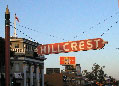 businesswomen in 1940. Originally hung from wooden posts, the sign has seen numerous alterations over the past six decades including a rebuilding/relighting in 1984 and an addition of post decorations in 1994. Just west another vintage neon sign marks Jimmy Wong’s Golden Dragon, the neighborhood’s oldest ongoing restaurant. In August of 2011 the HBA replaced the neon sign with an LED version then held an online auction of the replica in February 2012 for $5,200.
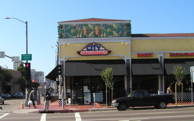 2. Kahn Building. 535 University Avenue. Constructed in 1919 this building first housed a Piggly Wiggly – but this grocery, also had a pharmacy and soda fountain. Designed at the height of the Egyptian Revival, the frieze at the corner originally featured pharaohs. The Egyptian fad was fading fast when the building was reconstructed following a fire in 1921. The cornucopia of fruit and vegetables was added at this time and was initially covered in gold leaf. The portion that City Deli occupied for nearly 30 years has continuously housed a restaurant for over 80 years. Most famous was Caesar’s, operated from 1923-1972 by the Cardini family. (Caesar created the famous salad that still carries his name.) Presently it is the site of Harvey Milk Diner. During WWII, the collection of the San Diego Natural History museum was displaced to make room for naval hospital beds. Mounted fish from the museum were displayed on the high interior walls of Caesar’s Cafe.
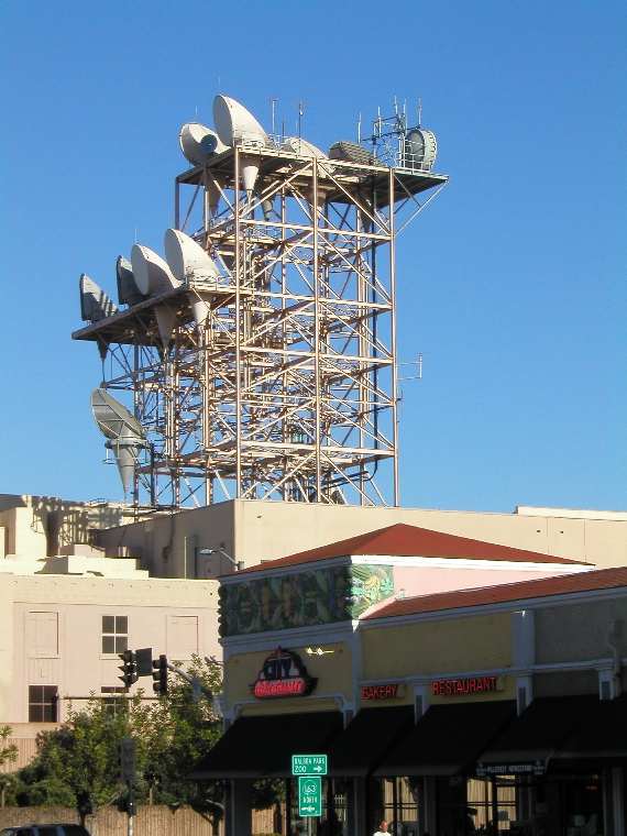 3. AT&T Building. 600 block University Avenue. This block has been a primary location of telecommunications equipment since 1915 when Pacific Bell and Telephone opened an exchange center to handle all of San Diego’s long distance calls. Operators then routed all calls by hand at large banks of switchboards. In 1937 the building expanded for installation of mechanical switches to route calls for the increasingly popular dial phones. The building has been expanded and modified numerous times over the decades in response to new technology as well as the deregulation of telecommunications. The large horns on the central tower are microwave transmitting and receiving antennae, a broadband communication technology which is slowly giving way to the increased capacity of underground fiber optic cables. Prior to AT&T this building was owned by SBC.
4. House of Heirlooms. St. Josephs Hospital (the precursor to Scripps/Mercy Hospital) occupied this building from 1891 to 1924. The House of Heirlooms building was erected in 1919 as a surgery annex. Lodging for the nursing school still survives as residential hotels just to the north on Eighth Avenue.
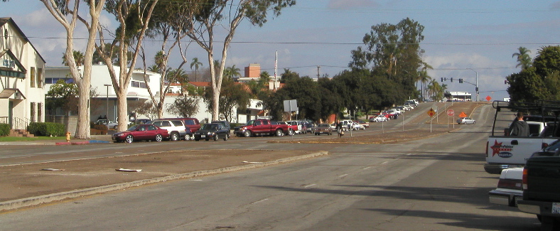
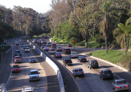 5. Cabrillo Freeway. Opening in 1947, the Cabrillo Freeway provided a “modern" automobile freeway connection between downtown San Diego and the growing housing developments to the north and east. Prior to the construction of I-8 through Mission Valley in 1958, eastbound traffic would exit at Washington Street and follow El Cajon Blvd (then US-80). Buildings once lined both sides of University Avenue before the trench was cut for the roadway.
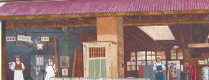 6. Ace Hardware Mural. Tenth Avenue south of University. Painted in 1999 by Linda Churchill.
7. Rich’s. 1051 University Avenue. Originally built as a furniture warehouse, this site has been home to a progression of nightclubs since the 1950s. Mickie Finn’s speakeasy featured the popular beauty singing and playing the banjo. In 1966 the sing-along show was nationally broadcast on TV from a set replicating the cozy pub interior. Rich’s, a popular gay club located here since 1991, features dancing and theme nights ranging from Studio 54 to Club Hedonism. A streetcar stop was located here till the line shut down in 1949. The Original French Laundry, a commercial building designed by Frank P. Allen was located across the street from here.
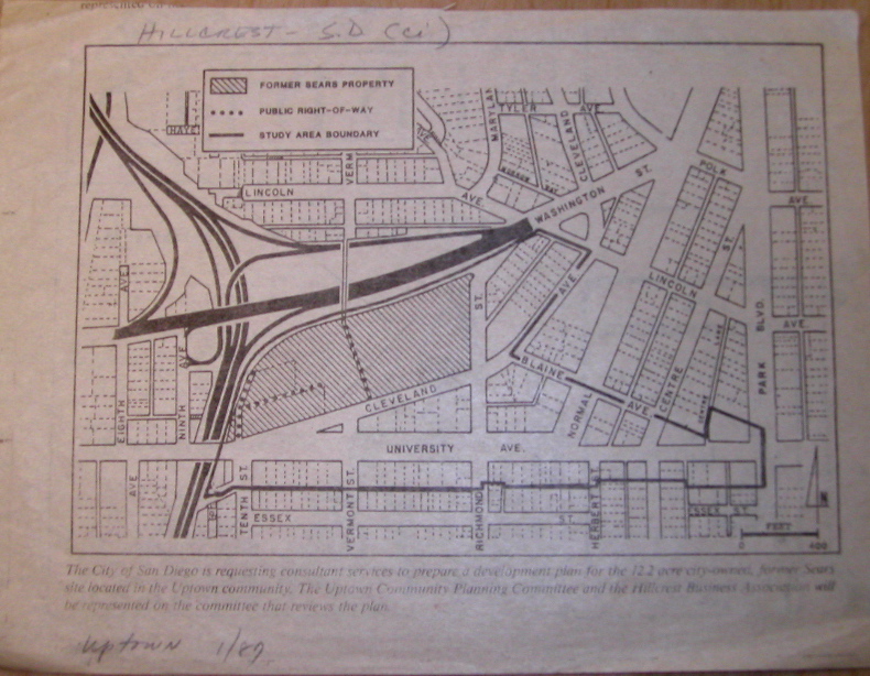 8. Uptown District. The neighborhood’s first experiment with mixed-use development, the Uptown District houses 318 residential units and a variety of retail stores. In September 1986, the City of San Diego purchased the 14-acre abandoned Sears store and surrounding parking lot for $9 million. Though the site was originally intended to house the city’s new central library, the City Council – with input from citizens groups including Uptown Community Planners and the Hillcrest Business Association – decided to revitalize the area with additional housing and retail.
Construction of the $70 million project was completed in 1990 and has attracted national attention as a model for redeveloping low density, obsolete commercial sites for new housing and community uses. The project served as the cover story of the June 1990 edition the monthly journal of the Urban Land Institute and is featured as a case study for “unsprawl" at www.Terrain.org. The Joyce Beers Community Center is located here. Stop in at Trader Joe’s market to see several historic neighborhood photos.
 9. Vermont Street Bridge. A wooden trestle pedestrian bridge was first built across this canyon in 1916. The original bridge was in operation until 1978 when rot and decay forced its closure. The modern steel bridge opened in 1995 and incorporated public art designed by the firm Stone Paper Scissors. Artists Lynn Susholtz, Aida Mancillas and Gwen Gomez created 32 laser cut panels which include pictographs and quotations about everyday life.
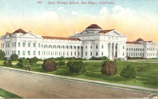 10. State Normal School Annex. The forerunner of today’s San Diego State University began here as the San Diego Normal School, a training facility for elementary school teachers. The original buildings are all gone except for a 1910 annex designed by William Hebberd. The neoclassical building is located on the northeastern corner of the campus overlooking the intersection of Washington Street and Park Blvd. San Diego State moved to its present location in 1931, and the grounds have since been used for public school classrooms and administration.
 along the way to 11… Normal Street. Owes its width to the trolley tracks once laid in the median. The parking lot of the DMV is the site of the weekly Hillcrest Farmers Market.
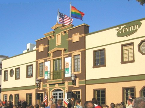 11. The LGBT Center. (3909 Centre Street) This old union hall has been remodeled and is presently occupied by the Center, home to San Diego County’s lesbian, gay, bisexual and transgender community since 1998.
12. The Marquis. (1751 University Avenue) This apartment block (once named Casa Grande Apartments) was built as housing for the 1915 Exposition.

13. Egyptian Revival Block (3800 Park Boulevard) Stroll Park Boulevard between Robinson and University to see how many reminders of King Tut you can espy.
14. Andrew Cunanan Apartment (1234 Robinson Avenue). In 1997, Hillcrest resident Andrew Cunanan went on a nationwide killing spree ending with the murder of Gianni Versace in Miami Beach.
15. Irving Gill Cottages (3757 Eighth Avenue) Four cottages designed by Irving Gill in 1910 for Mary Cossit.